
..........................................................................................................................................................................................................
carte du tour - paul fournel. rapha editions/bluetrain publishing hardback. 248pp illus. £40 (special limited signed edition £200)
on my recent visit to a neighbouring isle, i was delighted to be housed in their local field centre, accommodations that are mostly employed throughout term-time to host schoolchildren, many of whom come from regions that are anything but rural in their make-up. in fact, on my day of arrival, the surrounding rooms were filled by kids from south london, where tall green hills, a loch or two and a calmac ferry are quite likely conspicuous by their absence. i have no idea of what their visit to a scottish isle consisted, but i can assure you, they need no lessons in slamming doors in the early hours of the morning.
by the time i arose the following morning, they had departed for the early ferry and were later replaced for the weekend, by a group of geology students. according to my hosts, the latter were spending a long-weekend creating small grids on nearby ground in order to study the constitution of local, yet historical rockfalls. i fervently hope that their examination of rock strata bore greater fruit than their search for the tomato sauce bottle at breakfast. some things you apparently can't teach.
though my grasp of the rudiments of geology is pretty much non-existent, i cannot deny an awareness of the basics of sedimentary examinations, where the history of millennia can be ascertained from the composition of exposed rocks. it's a time-lapse look at the world that can take us back to the age of the dinosaurs, and is possibly the only realistic means of an appraisal heading back quite so many thousands or millions of years. more recent history is, by comparison, far easier to research and in greater detail, particularly from around the mid-fifteenth century when johannes gutenberg invented the printing press.
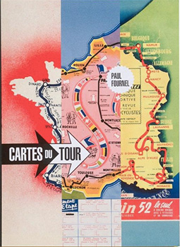
this is something particularly pertinent to this superb, large-format book that forms another part of the rapha edtions collection, one which includes andy mcgrath's award-winning book about the ill-fated tom simpson. co-published by guy andrews' blue train publishing, paul fournel's carte du tour is a tad more substantial in format than the preceding 'getting started in road racing', this one appearing in a cloth-bound, coffee table size book that features a map of the tour de france from every year since 1903. it's probably worth my pointing out that the edition for the race currently underway, is far less impressive than that which appeared on the front page of l'auto on 1 july 1903.
for most of us, a map, is a map, is a map; the sort of device (and i do not use that word lightly) we use to get us safely and speedily from a to b. call up google maps on your web browser and you can even drag the little yellow fellow in the corner onto the roadway of your choice and it's possible to take a three-dimensional walk through the neighbourhood. those first maps of the tour de france parcours were utterly devoid of topographical information, providing simply the names of towns, villages and cities through which the nascient grand tour was due to travel.
author and respected race historian, paul fournel, commences this historical cartographic journey by introducing us to the man who made it all possible, henri desgrange.
"He wanted this event to be nothing less than the biggest, hardest, and best sporting event of the year. It had to be spectacular and unbearable."
even today, it seems likely that desgrange's wishes continue to be fulfilled on an annual basis. strangely, for a newly introduced, large-format sporting event, the maps become somewhat less than truly functional through the years of 1906 to 1909, being almost unremarkable even in a graphic sense. however, from 1907, tour de france cartography took an upward swing in quality, the latter year fillling the centre of the country with stuck-on photos of the race's three favourites (georget, van houwaert and garrigou). the historical aspect of le grande boucle is precis'd with remarkable skill by monsieur fournel, including such as alphonse steines' suggestion to desgrange that he take the race over the pyrenees. steines was duly sent to reconnoitre...
"At daybreak, the police found him in the snow, frozen and haggard.
"They took him back down to the town.
"After a nice hot bath and a substantial snack, Steines - having come round - phoned Desgrange: 'It's good; we can go."
for those of us who exhibit pecadilloes not always present in the average cycling aficionado, those maps offer a secondary level of intrigue: that of typography. for instance, in the map published in l'auto on 2 july 1910, the countries surrounding french france are delineated in a spidery, hand drawn typeface, while the central region of the country is impressed upon by a sturdy and varying set of woodtype lettering, including that of l'auto which features in blackletter.
humour me.
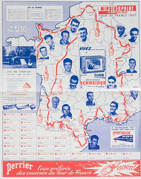
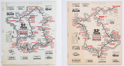
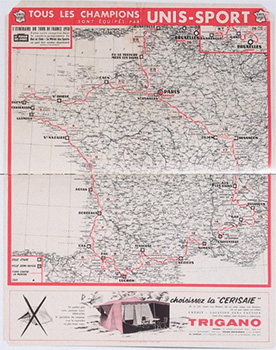
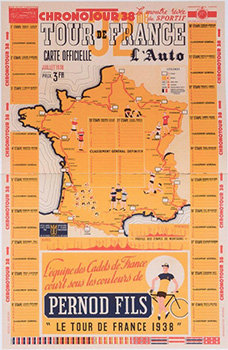
cartes du tour is a fascinating volume, printed as it is on heavy art paper, with reproduction of the well-researched maps (credit is due to guy andrews, i believe) often little short of breathtaking. the predominantly blue, red and orange map of 1938 (see right) features a border allowing the lucky recipient to fill in the first four on each stage along with the general classement, while that of 1956 is quite basic but decorated with caricatures on bicycles. the latter, oddly enough, is a theme that was delightfully repeated sixty years later in 2016. the variety is endless and impressive. disappointingly, the official maps provided by aso in recent years seem positively lacking in inspiration by comparison with many of their antecedents.
it is not often that a writer of the stature of paul fournel is overshadowed by a co-star, even if that co-star inhabits a cartographic demeanour and it is with the greatest of respect that i contend that this is one of those rare occasions. the accompanying text appears in both french and english and it is hard to consider this running commentary arising from the pen of anyone other than the author of 'need for the bike' and 'anquetil alone'. i wonder what is the french word for 'succinct'? many books of this size concerning the tour de france seem only to occupy the moment created by those three weeks in july. i think it more than likely that cartes du tour will have a considerably longer lifespan.
cartes du tour by paul fournel
friday 13 july 2018